- Philadelphia and Southeastern PA: Heatwaves, Severe Storms, Flash Floods, Flash Droughts, Extreme Winds, Microbursts, Tornadoes
- Barrier-Islands From the Jersey Shore to the Outer Banks
- The I-95 Corridor: Severe Storms, an Expanding “Tornado Alley,” Straight-Line Winds, and the Urban Heat Island
- Pennsylvania: When the Levee Breaks — Crying Won’t Help You, Praying Won’t Do You No Good
- Chester County, It’s Shocking: Lightning Strikes Are Surging
- Chester County: Rapid-Fire, Near-Continuous Cloud-to-Cloud Lightning
- West Chester, Pennsylvania: Urban Flooding — Unfortunately, Worms Can’t Swim
- West Chester, Pennsylvania: Hydroclimatic Whiplash and Flash Droughts — Unfortunately, Millipedes Can’t Swim
- The Backyard Experiments: Hydroclimatic Whiplash, Soil Degradation, Insect Decline, and Ecosystem Collapse
- Coatesville, PA: Hydroclimatic Whiplash — Dying of Thirst in a Flood
- Backyard Megapitfall Traps: A Changing Ecosystem for Frogs, Spiders, and Worms
- The Jersey Shore and Florida Coast: Sea Level Rise, Inverse Barometer Effect, Wind Stress, Flooding, Saltwater Intrusion
Category: Montgomery County PA
bookmark_borderHow Is Climate Energy Hitting You?
When Lightning Strikes: The Delaware Valley’s Escalating Severe-Storm Pattern
Lightning strikes are increasing primarily because rising global temperatures act as fuel for thunderstorms, generating greater atmospheric instability and moisture. According to peer-reviewed atmospheric research published in the journal Science, cloud-to-ground lightning strikes are projected to increase by approximately 12% for every 1°C (1.8°F) of global warming. Under current warming trends, this could result in an estimated 50% increase in lightning strikes across the United States by the end of the century.
The impact is already striking the Philadelphia region in a shocking way. The summer of 2026 has seen a record amount of power surges and outages across much of the area. In West Chester, Pennsylvania, scores of power-related incidents have resulted in significant damage to electronic systems.
About Last Night
The Philadelphia region is recovering from a major outbreak of severe storms on Tuesday night, September 1, 2026, while remaining under weather alerts for additional incoming storms through Thursday.
A dangerous combination of high heat, intense humidity, and a passing cold front sparked widespread damage across the Delaware Valley, including flash flooding, destructive wind gusts, and multiple tornado warnings.
Current Storm Coverage & Recent News
Widespread severe storms rolled through the Philadelphia area, prompting a total of 19 Severe Thunderstorm Warnings and five Tornado Warnings. There were numerous reports of damage from downed trees and power lines, roof damage, and flooding.
Current post-storm tracking shows that Chester County was hit the hardest in southeastern Pennsylvania.
Key Impacts and Damage Reports
Event Disruptions
The severe weather forced the evacuation of concertgoers and disrupted a Bruno Mars concert at Lincoln Financial Field.
Tornado Threats
Radar-indicated rotations prompted five distinct Tornado Warnings, including a prominent warning for central Burlington County, New Jersey, that neared the National Weather Service office in Mount Holly. These warnings have since expired or been canceled.
Flooding
Widespread Flood Warnings were active for Chester, Delaware, Camden, and Gloucester counties.
In Williamstown, in Monroe Township, emergency responders reported multiple roadways completely submerged under water.
Structural & Utility Damage
High-speed wind gusts of up to 65 mph downed trees and power lines, particularly blocking major roads such as Morgantown Road in West Nantmeal Township.
More Than 1,000 Lightning Strikes
More than 1,000 lightning strikes were officially recorded in neighboring northern Delaware alone as the massive storm system moved through the region Tuesday night.
A comprehensive, exact count covering the entire tri-state Philadelphia metropolitan area—including southeastern Pennsylvania and southern New Jersey—had not been finalized by the National Weather Service. Local reports nevertheless highlighted exceptionally frequent cloud-to-ground lightning throughout the Delaware Valley.
This intense electrical activity contributed to widespread power outages, knocking out electricity to nearly 60,000 customers in Pennsylvania.
The 20-Year Pattern
Over the past 20 years, the severe-storm pattern in the Philadelphia region has been defined by a sharp increase in multi-hazard extreme events, characterized by heavier downpours, more frequent flash flooding, and higher financial impacts.
While meteorologists note that the overall frequency of baseline thunderstorms has remained relatively flat, the intensity of the region’s peak storms has surged significantly, driven by rising summer temperatures and a more humid atmosphere.
1. Heavier, Rapid Rainfall and More Intense Microbursts
The most measurable shift in the Delaware Valley is the dramatic increase in hourly rainfall rates.
The Trend
The Northeast United States has seen a 60% to 70% increase in very heavy rainstorms since the mid-20th century.
Instead of steady, prolonged rainfall, storms over the past two decades increasingly dump massive amounts of water within highly localized windows.
Local Example
During severe storms on July 11, 2026, parts of West Philadelphia recorded one inch of rain in just five minutes, triggering immediate urban flash flooding.
Straight-Line Winds
The region has experienced a noticeable pattern of violent microbursts and straight-line winds reaching up to 70 mph.
These winds can mimic tornado damage while covering much wider geographic areas.
2. Multi-Day Stagnant Storm Patterns
Instead of a single line of storms passing through and clearing the air, the past 20 years have seen an increase in consecutive-day severe-weather threats driven by blocking patterns in the atmosphere.
The Trend
High-pressure “heat domes” can lock intense heat and moisture over the Mid-Atlantic, fueling successive waves of storms.
Local Example
The September 2026 outbreak marks a rare multi-day stretch during which Philadelphia has been placed under a continuous Level 2 out of 5 severe-storm threat for three straight days.
According to the supplied material, this phenomenon has been mirrored only a couple of times over the past 20 years, including 2023 and 2008.
3. Surge in “Billion-Dollar” Severe Disasters
The financial and societal toll of storms tracking through Pennsylvania has spiked dramatically.
The Trend
Between 1980 and 2024, Pennsylvania averaged roughly 2.5 billion-dollar weather events per year.
However, during the more recent five-year period of 2020–2024, that average skyrocketed to approximately 8.2 billion-dollar events annually, heavily driven by severe convective storms and tropical-system remnants.
Pennsylvania’s Billion-Dollar Weather Disasters, 1980–2024
| Disaster Type | Confirmed Billion-Dollar Events |
|---|---|
| ⛈️ Severe Convective Storms | 64 |
| ❄️ Winter Storms | 20 |
| 🌀 Tropical Cyclones / Hurricanes | 16 |
| 🍂 Droughts & Freezes | 9 |
| 🌊 Inland Flooding | 5 |
Data source: NOAA National Centers for Environmental Information
Severe storms therefore heavily outpace every other major climate-disaster category in Pennsylvania, establishing themselves as the state’s dominant recurring threat.
How Many Weather Disasters?
Pennsylvania was impacted by 41 confirmed billion-dollar weather and climate disasters between 2020 and 2024 alone, with additional severe storms, historic tornado spikes, and winter emergencies officially continuing into 2025 and 2026.
Because comprehensive, inflation-adjusted billion-dollar disaster tracking is cataloged retroactively and can involve a multi-month lag, the precise financial tally for 2025 and 2026 is still being finalized.
Nevertheless, state and federal tracking highlight a historically volatile six-year window for the Commonwealth.
The 2020–2024 “Billion-Dollar” Footprint
During this five-year baseline, Pennsylvania experienced a massive uptick in severe weather, averaging approximately 8.2 major disasters per year, compared with a historical average of just 2.5 per year since 1980.
The 41 confirmed events included:
Severe Convective Storms
The overwhelming majority involved destructive straight-line winds, baseball-sized hail, and localized tornado outbreaks.
Tropical Systems
Remnants of major hurricanes—including Hurricane Ida in 2021—produced devastating flooding. Ida brought deadly, record-breaking flooding to the Vine Street Expressway, or I-676, in downtown Philadelphia.
Tropical Storm Debby in 2024 also contributed to major regional impacts.
Winter Storms & Freezes
Major deep freezes and heavy snow events also tracked through the Northeast, producing additional significant weather disasters.
2025–2026: The Pattern Continues
The trend of severe weather has shown no signs of slowing down over the last two years.
2025: Tropical and Convective Triggers
Summer storms continued to hammer the region.
Tropical Storm Chantal in July 2025 caused as much as 4.3 inches of rain in short windows and triggered a ground stop at Philadelphia International Airport.
2026: Record Tornadoes & Winter Storms
Pennsylvania has experienced an unprecedented, record-breaking surge of at least 20 confirmed tornadoes so far in 2026, heavily driven by unusual summer heat dynamics.
The year also began with major winter emergencies. The Governor issued back-to-back State Disaster Emergency Proclamations for severe winter storm systems impacting the Commonwealth in January and February 2026.
Five Years of Severe Weather in the Philadelphia Region: 2021–2026
The five-year history of the Philadelphia region highlights a dramatic shift into an era of extreme-weather anomalies, featuring destructive tropical remnants, record-breaking tornado outbreaks, and multi-day severe convective storms that have severely stressed the local energy grid.
A year-by-year retrospective reveals how the Delaware Valley’s weather pattern has evolved.
2021 — The Benchmark Year for Flooding & Tornadoes
Key Storm Event
On September 1, 2021, the remnants of Hurricane Ida struck the Philadelphia region, establishing itself as a generational disaster.
Ida generated an unprecedented flash-flood emergency, completely submerging the Vine Street Expressway, I-676, in downtown Philadelphia under feet of water and pushing the Schuylkill River to historic, devastating crests.
Tornado Surge
Earlier that summer, on July 29, 2021, a rare macro-environmental setup produced a high-density tornado outbreak in southeastern Pennsylvania.
This included a massive EF-3 tornado that tore through Bensalem and became one of the widest tornadoes recorded in city history.
2022 — The Grid Modernization Pivot
Key Weather Trend
Compared with the years surrounding it, 2022 was a relatively stable convective year for the immediate Philadelphia area, logging fewer catastrophic regional washouts.
Utility Impact
Taking advantage of the brief reprieve from major weather anomalies, local utility providers completed more than 430 reliability and resiliency projects.
The massive grid-hardening effort was designed to reinforce aging infrastructure against future high-wind storms by installing stronger poles and tree-resistant aerial cables.
2023 — High Heat and Air-Quality Crises
Key Storm Event
Severe summer convective squall lines routinely marched through Chester, Montgomery, and Delaware counties, heavily driven by extreme atmospheric instability, or CAPE.
Environmental Context
The severe storms of 2023 were uniquely preceded by prolonged stretches of extreme heat and hazardous air quality, heavily influenced by smoke drifting from massive Canadian wildfires.
The combination illustrated how multiple environmental stresses can overlap: heat, atmospheric instability, smoke, and severe convection.
2024 — A Thirty-Year High for Power Failures
Key Weather Trend
The Pennsylvania Public Utility Commission officially noted that 2024 reset a 30-year high for reportable power outages across the state.
More than 2.8 million Pennsylvanians lost power at some point during the year.
Key Storm Event
The remnants of Tropical Storm Debby swept through the region in August, bringing intense tropical moisture that caused widespread local flood emergencies, downed old-growth trees, and fractured localized infrastructure.
2025 — Unseasonal Hail and High Outage Rates
Key Storm Event
In June 2025, a sudden, powerful derecho-like convective line brought severe storms that knocked out power to more than 327,000 PECO customers across the Philadelphia area.
The event ranked among the top 20 worst blackouts in regional utility history.
Late-Season Anomalies
The volatile weather stretched later into the season than usual.
Tropical Storm Chantal, later in the summer, forced airport ground stops at Philadelphia International Airport after dumping more than four inches of rain in just a few hours.
2026 — Microbursts, Extreme Heat, and Disaster Declarations
Winter Chaos
The year began with a highly volatile winter pattern.
The Governor issued consecutive State Disaster Emergency Proclamations in January and February because of major, ice-laden winter storms that froze regional transportation networks.
Summer Declarations
In July 2026, severe heat waves sparked extreme thunderstorms featuring four distinct microbursts and straight-line wind gusts of 60 to 70 mph across West and South Philadelphia.
The intense winds caused building collapses, knocked down hundreds of trees, and forced Mayor Cherelle Parker to issue a citywide Declaration of Disaster Emergency.
The Pattern Is the Story
Look at the sequence:
Heat.
Humidity.
Atmospheric instability.
Extreme rainfall.
Lightning.
Microbursts.
Straight-line winds.
Tornado warnings.
Flash flooding.
Power outages.
Infrastructure damage.
Repeated storms.
The individual events are different, but they share a common characteristic: large quantities of atmospheric energy being released over increasingly consequential periods and places.
The important question is not simply whether the Philadelphia region is experiencing more ordinary thunderstorms.
The more important question is whether a warmer, more humid atmosphere is helping the strongest storms become more intense, wetter, more damaging, and more disruptive.
And the evidence presented here points to an increasingly consequential pattern.
The Delaware Valley is not simply experiencing storms.
It is experiencing multi-hazard weather events that combine several forms of atmospheric energy release at once.
Lightning makes that energy visible.
Flooding makes it physical.
Wind makes it destructive.
Tornadoes make it violent.
Power outages make it personal.
And when these hazards repeatedly strike the same region, they become something larger than isolated weather events.
They become a stress test for the systems on which everyday life depends.
That is how climate energy is hitting you.
bookmark_borderCanadian Wildfire Smoke Returns: A Growing Summer Threat to Philadelphia’s Air Quality
by Daniel Brouse
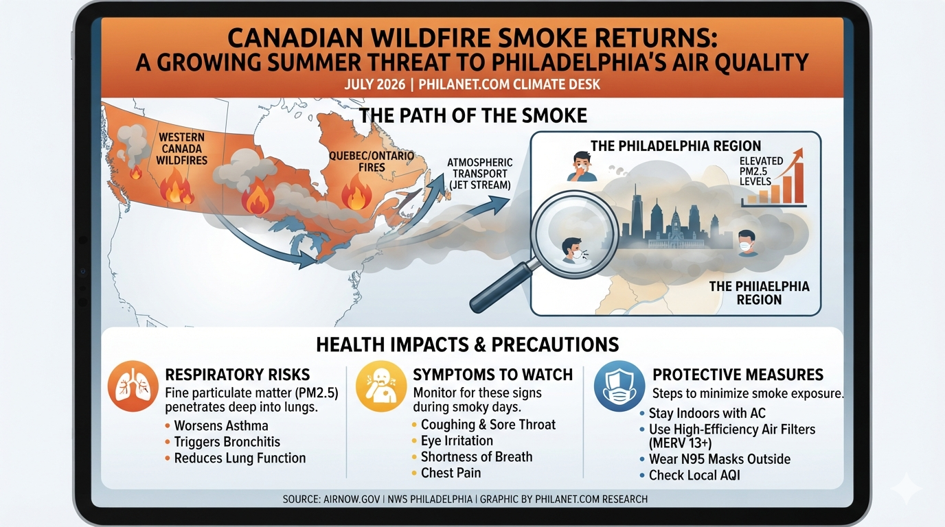
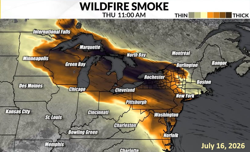
Canadian wildfire smoke is once again drifting into the Philadelphia region, bringing hazy skies, reduced visibility, and deteriorating air quality. Over the next 24 to 48 hours, meteorologists expect a thick plume of smoke to spread across the Delaware Valley as winds transport emissions from large wildfires burning across Canada.
The smoke arrives at the same time an intense near-record heat dome is pushing local temperatures toward 101°F, creating a dangerous combination of extreme heat and air pollution.
A Double Environmental Threat
According to the U.S. National Weather Service in Philadelphia/Mount Holly, smoke from Canadian wildfires is being carried across the Great Lakes and into the northeastern United States. While the smoke may remain high in the atmosphere at times, periods of surface-level smoke can significantly reduce air quality.
The simultaneous occurrence of extreme heat and wildfire smoke amplifies health risks, particularly for vulnerable populations including:
- Children
- Older adults
- Pregnant women
- People with asthma or COPD
- Individuals with heart disease
- Outdoor workers
- Athletes exercising outdoors
Heat stresses the cardiovascular system, while fine smoke particles place additional strain on the lungs and heart.
Current Conditions and Forecast
Residents across southeastern Pennsylvania, New Jersey, and Delaware should expect:
- Smoky, hazy skies with noticeably reduced visibility.
- Dimmed sunlight, giving the sky a milky or orange appearance.
- Extreme Heat Warnings, with heat indices between 100°F and 109°F.
- Worsening air quality, as concentrations of fine particulate matter (PM2.5) increase.
Even when the sky does not appear especially smoky, microscopic particles can remain suspended in the air and pose health risks.
Why Wildfire Smoke Matters
Wildfire smoke contains a complex mixture of gases and microscopic particles. The greatest concern is PM2.5—particles smaller than 2.5 micrometers in diameter. These particles are small enough to bypass the body’s natural defenses and penetrate deep into the lungs, where they may enter the bloodstream.
Exposure to elevated PM2.5 has been linked to:
- Asthma attacks
- Reduced lung function
- Eye, nose, and throat irritation
- Heart attacks and strokes in susceptible individuals
- Increased emergency room visits
- Premature mortality during severe pollution episodes
Even healthy adults may experience coughing, sore throat, headaches, fatigue, or shortness of breath during periods of elevated smoke.
How to Protect Yourself
Because extreme heat and wildfire smoke are occurring simultaneously, taking precautions is especially important.
Stay indoors whenever possible. Keep windows and doors closed, particularly during the afternoon and evening when pollution levels often peak.
Use air conditioning. Operate your HVAC system on the recirculate setting to reduce the amount of outdoor air entering your home. A MERV 13 or higher filter can significantly improve indoor air quality.
Limit strenuous outdoor activity. Running, cycling, heavy yard work, and other vigorous exercise increase breathing rates, causing more smoke particles to be inhaled.
Monitor the Air Quality Index (AQI). Air quality conditions can change rapidly depending on wind direction and the movement of smoke plumes.
Consider wearing a properly fitted N95 respirator if you must spend extended periods outdoors during heavy smoke conditions. Cloth masks and surgical masks do not effectively filter PM2.5 particles.
A New Summer Reality
Canadian wildfire smoke has affected the eastern United States every summer since 2023, highlighting a growing environmental challenge. Warmer temperatures, prolonged droughts, and longer fire seasons have contributed to increasingly large and persistent wildfires across Canada.
As these fires become more frequent and more intense, smoke transport over thousands of miles is becoming an increasingly common feature of summers across the Northeast.
For residents of Philadelphia and much of the East Coast, hazy skies that were once considered unusual are now becoming part of the seasonal weather pattern.
Looking Ahead
While individual smoke events may last only a day or two, they illustrate a broader trend toward more frequent climate-related air quality disruptions. Preparing homes with effective air filtration, monitoring local air quality forecasts, and adjusting outdoor activities during smoke events are becoming practical components of summer health planning.
For now, Philadelphia residents should prepare for hot temperatures, smoky skies, and reduced air quality over the next several days and take appropriate precautions until the smoke plume moves out of the region.